1. Background
Under the background of big data era, in order to meet the major needs of the country in the field of spatial information and geological industry information construction, our institute relies on the national key disciplines of geological resources and geological engineering and the key disciplines of computer science and technology in Hubei Province to integrate modern computer technology, spatial information technology and earth science, In 2010, an experimental class of "spatial information and digital technology" was held, aiming to cultivate the interdisciplinary innovative talents of Geoscience and modern information technology. In 2013, "spatial information and digital technology direction" was officially included in the college entrance examination enrollment plan. In 2014, the undergraduate major of "spatial information and digital technology" was successfully approved by the Ministry of education. In 2015, the major was selected into the talent training program for strategic emerging (pillar) industries of Hubei ordinary colleges and universities, and was approved as the pilot project for comprehensive reform of major by the Ministry of education. In 2018, the professional construction project won the first prize of teaching achievements of Hubei Province. The major construction goal of this major is to cultivate compound innovative talents and to achieve a leading position in geoscience information technology. At present, the major has developed into a new engineering major which is widely used in the air, space, earth, sea and the whole space, and adapts to the construction of digital earth and glass earth.
2. Objectives
Major training objectives:Students trained in this major have correct world outlook, values, rigorous scientific style, professional knowledge and healthy body, and systematically master basic theories, methods and skills in computer technology, spatial information technology, big data technology, artificial intelligence technology, geoscience information system engineering, etc. Students trained in this major are compound innovations. New talent can be engaged in scientific research, teaching and management in a variety of high-tech fields related to the spatial information specialty, and can also enter the related disciplines and fields of domestic and foreign scientific research institutes to continue their further study. After about five years of training, graduates trained in this major can become technical leaders or key members of their units or departments and intermediate (including) or higher levelengineers.The students trained in this major have the following qualities and performances:
(1) Realistic and pragmatic, innovative and enterprising, team spirit and sense of social responsibility;
(2) Have a solid foundation in mathematics, computing science, spatial information and digital technology;
(3) Be able to go deep into the specific needs of the space complex engineering industry, design digital, information, intelligent solutions;
(4) Be able to carry out effective practice in the field of work and get reasonable and effective conclusions through innovative thinking;
(5) Have a certain international vision and track the development of space information frontier field insight;
(6) Can constantly update knowledge through self-study to adapt to the rapid development and change of society and science and technology.
3. Requirements
The following is a list of the knowledge abilities and qualitythat a qualified undergraduate majoring in spatial information and digital technology should possess:
(1) Engineering knowledge: Mastering the fundamental knowledge of mathematics, computer related professional knowledge in spatial information and digital technology engineering, as well as some basic knowledge and skills in spatial information and digital technology, and applying it to space complex engineering practice.
(2) Analytical ability: Possessing the ability to find, analyze and solve problems, and applying the basic principles of mathematics, natural science and engineering science to analyze complex engineering problems in the field of spatial information and digital technology to obtain effective conclusions
(3) Design ability: Determining basic ideas and schemes according to the demand of spatial information and digital technology complex engineering problems, demonstrate the feasibility of design schemes through information technology and intelligent technology under the realistic constraints of social, cultural, economic, low, safety, and environment, and design digital, informationized and intelligent solutions for specific needs of geoscience-related industries. It can embody innovative consciousness in design.
(4) Research ability: Integrating professional knowledge, and then have a solid basic theory and research method of spatial information science; studying complex engineering problems in the field of spatial information, and generating innovative consciousness and thinking; Having the ability to solve the analysis, expression and application of spatial information.
(5) Practical operation ability: Making full use of modern communication and transmission equipment, digital equipment, computer information exchange and processing to solve the complex engineering problems, and having the ability to propose the solution for complex hardware systems, software systems or application systems; predicting and simulating the complex software engineering problems as well as computer operation.
(6) Ability to integrate into society: Conducting rational analysis based on engineering-related background, evaluate the impact of professional engineering practices and complex software engineering problem solutions of spatial information and digital technology on society, health, safety, law and culture, and understand the responsibilities to be undertaken.
(7) Environment awareness: to understand and evaluate the impact of engineering practices on environmental and social sustainable development for spatial information and digital technology complex problems, and to reflect the requirements of environmental and social sustainable development in solutions.
(8) Professional norms: with humanities and social sciences literacy, social responsibility, understand and abide by engineering professional ethics and norms in spatial information and digital technology engineering practice, fulfill their responsibilities.
(9) Collaboration and leadership: to take on the roles of individual, team member and leader in a multi-disciplinary software project team with team spirit.
(10) Communication ability: effectively communicate with colleagues in the industry and the public on spatial information and digital technology complex engineering issues, including writing project applications, reports and software documents, presenting statements, clearly expressing or responding to instructions, and have a certain international perspective, and can communicate in a cross-cultural context.
(11) Management ability: understand and master the principles of spatial information and digital technology engineering project management and economic decision-making methods, and can be applied in a multi-disciplinary environment.
(12) Lifelong learning: with the awareness of lifelong learning and the ability to use modern information technology to obtain relevant information and new knowledge, new technology, can adapt to the requirements of development through continuous learning.
4. Subject Foundation (Platform) Course
This major has the following specialized basic courses or platform courses: Spatial Information Perception, Spatial Information Networks, Geoscience Theoretical Basis, Comprehensive Exploration, Object-Oriented Programming, Principle of Spatial Database, Spatial Data Analysisand Mining, Remote Sensing Image Processing, Big Data Platform and Application, Artificial Intelligence, Machine Learning, Three-Dimensional Visualization and Process Simulation, Geographic Information System, Modern Software Engineering, Geographic Information System Engineering, Cloud Computing and Virtualization, Spatial Information Services, Smart Cities, and so on.
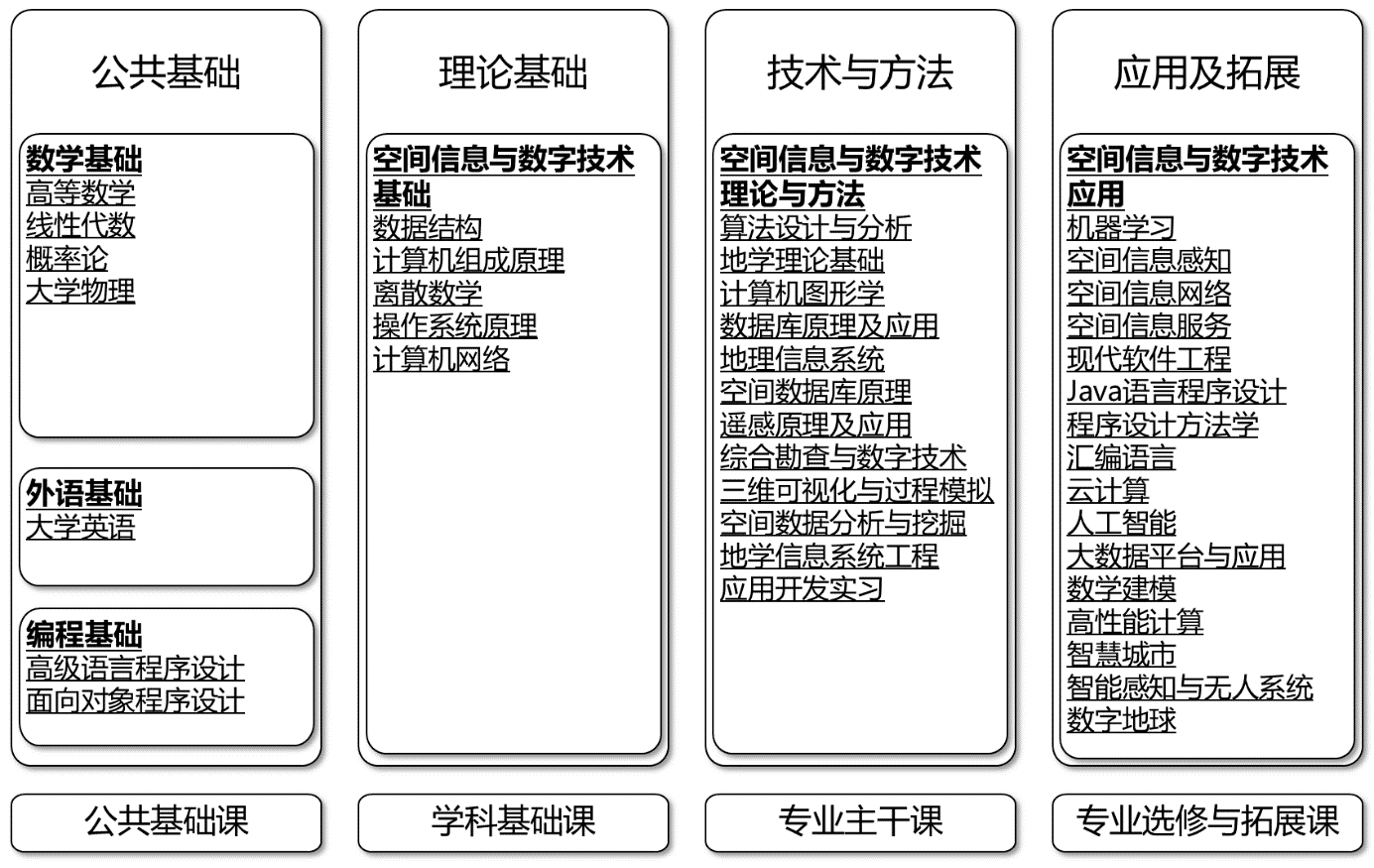
Hierarchical relationship between spatial information and digital technology courses
This major vigorously promotes research-oriented teaching, establishes undergraduate tutorial system, guides and promotes students to form teams and build research platforms, enables students to enter the scientific research field and laboratories as soon as possible, and takes leading students to advanced research as an important way to train innovative talents. This major pays special attention to developing various forms of practical teaching, training students' practical and innovative abilities, reforming and optimizing the experimental course system, integrating practical teaching links, and making overall coordination between theoretical and practical teaching. The practical teaching links of this major include course experiment, course design, software comprehensive practice, geological teaching practice (Zigui), application and development practice, professional practice and graduation design (paper) which form a practical teaching system. Geological teaching practice is organized by combining field geological practice with computer indoor teaching.When students are practicing field geology teaching, we equip them with palmtop computers to collect field data. The students then input the data collected in the field into the digital mapping system of the Geological Survey Bureau for data processing, and finally complete the full electronic geological practice report. When students complete the field geological teaching practice, they complete a real project, and students can apply their theoretical knowledge to practice. QuantyView two-dimensional and three-dimensional experimental platform is adopted in professional practice. It requires students to complete comprehensive and designed experiments, so that students can get real professional training, which is equivalent to practice in software enterprises. The major continuously strengthens the construction of practical teaching bases. At present, the major has reached cooperation agreements with the following units, which are the newly increased practical teaching bases: Industrial Park Geospatial Information Industry Alliance of WuHan University (national geospatial information industry base), Zhongjiao Yuke (Beijing) Spatial Information Technology Co. Ltd., Jiangyan Smart Valley Software Park, Jiangsu Province, Kundi Science and Technology Co. Ltd. from theUniversity of Geosciences(WuHan), and Xinfei Company from the University of Science and Technology , etc.

The construction method of software R & D team in training students

Discussion on project development between teachers' group and students' project group

The student project team reports the final software development results to the teacher team
5. Faculty andTalent Training
With the core of famous teachers and professors / doctoral supervisors, this major is a high-level teacher team with reasonable knowledge structure, educational background structure and age structure, which is composed of 4 professors, 12 associate professors and 10 lecturers.Among them, there is one winner of "golden hammer Award" of Chinese Geological Society, one winner of Hubei Distinguished Young Scholars fund, and two winners of "Optics Valley talent plan" of Wuhan.All of the teachers have received doctorates, and 80% of them have visited famous foreign universities.In recent years, the professional teachers have undertaken and completed more than 60 national and provincial level projects, including the key projects of the National 863 plan, the national 973 Plan, the national major special projects, the key projects of the National Natural Science Foundation, the national "12th Five Year" Civil Aerospace pre research, etc., with a total research fund of more than 80 million yuan in recent five years.It published more than 180 papers in authoritative and core computer journals and important academic conferences at home and abroad. Five monographs have been officially published. The team has successively won one first prize of science and technology progress in Hubei Province, one first prize of technological invention in Hubei Province, two first prizes of teaching achievements in Hubei Province, and more than 50 national invention patents.
The major leader is Liu Gang, doctor, professor and doctoral supervisor. Vice president of Computer College of China University of Geosciences (Wuhan), vice director of Institute of geological information technology, executive chairman of National Committee of China, director of International Association of mathematical Geosciences (IAMG), executive vice director of Hubei Key Laboratory of intelligent geoscience information processing.It is mainly engaged in the teaching and research work of big data of Geosciences, 3D visualization modeling and analysis of geospatial space, spatiotemporal data model, etc.He presided over 1 key project of NSFC, 2 general projects, 1 National 863 key project and 1 key science and technology project of Ministry of education. He has published more than 90 papers, 2 monographs and 2 teaching materials, and won 6 national invention patents. He has participated in the research and development of the quantyview 3D visualization geoscience information system software platform, which has been widely used in the field of Geology and mineral resources. More than 60 doctoral and master's students were trained, of which 2 won excellent master's degree thesis of Hubei Province, the second prize of national "Challenge Cup" and the special prize of "Challenge Cup" of Hubei Province. He has won 1 first prize of provincial technology invention award, 1 first prize of provincial science and technology progress award, 1 special prize of Surveying and Mapping Science and technology progress award, 1 first prize, 2 first prizes of provincial excellent teaching achievements, the young geological science and technology award of China Geological Society-Golden Hammer Award, and the Griffiths teaching award of International Mathematical geoscience Association (IAMG).
Characteristics of professional personnel training: (1) relying on the doctoral and master's degree programs of "geoscience information engineering", the specialty has a high starting point, and has been selected into the strategic emerging (pillar) industrial personnel training program of Hubei Higher Education Institutions; (2) Relying on national and provincial key disciplines, it has national field practice base and provincial information technology experiment center; (3) The teaching team takes famous teachers, professors / doctoral supervisors as the core, with strong teaching force and high professional level; (4) It has formed a unique geoscience information technology composite talent training system, and won the first prize of teaching achievements in Hubei Province; (5) It has professional system teaching software with independent intellectual property rights widely used in the industry, and provides full range and full coverage of practical teaching support, including quantyview 3D visualization geoscience information system software, satellite constellation optimization design and task planning software system CSTK, etc.In recent years, the following achievements have been achieved in the major of Construction: (1) A distinctive training system of geological information composite talents has been formed, and the achievement "exploration and practice of the training mode of geological information technology composite innovative talents" has won the first prize of teaching achievements of colleges and universities in Hubei Province; (2) It has formed a well-designed training program for professional talents, embodying advanced teaching concepts and scientific and feasible curriculum system; (3) It has established national practice bases including Zigui field practice base, national virtual simulation experiment teaching center for mineral resource formation and exploration and development, Hubei Key Laboratory for intelligent geoscience information processing, spatial information and digital technology The practice teaching system of "multi-level, multi combination, multi-channel and one platform" in the technology laboratory; (4) A high-level teacher team with reasonable knowledge structure, educational background structure and age structure composed of 4 professors, 12 associate professors and 10 lecturers; (5) Establish a production university research base for the mainstream process of geoscience informatization. At present, it has established stable cooperation bases with National Geospatial Information Industry Base Wuda Industrial Park geospatial information industry alliance, China Communications Yuke (Beijing) Space Information Technology Co., Ltd. iFLYTEK Co., Ltd. and Wuhan dikundi Technology Co., Ltd. for students to participate in off campus enterprise social practice, which plays an important role in improving students' practical ability Write. There is a perfect professional teaching management system, and the management of students' graduation design is in place. The topics of graduation design (Thesis) are combined with practical engineering application, which conforms to the professional development direction and the needs of social talents; (6) High quality and popular graduates with reasonable knowledge structure and strong practical ability are cultivated. The graduation rate of the last three experimental classes is 100%, and the employment rate (including enrollment) is more than 95%. We have obtained excellent graduation class at school level for three times.
6.Career Prospects
With the development of the new generation of information technology, the society and the country are in urgent need of space information technology and spatial data processing talents. All kinds of spatial data professionals trained by this profession can serve the national strategy of smart earth, Internet plus action plan, big data, etc.The students majoring in spatial information and digital technology have great social needs and broad employment prospects. After graduation, they can be engaged in the fields or departments of high-tech such as natural resources, ecological environment, emergency response, digital earth, glass earth and smart city, transportation, national defense and military, aerospace, water and hydropower, and many software enterprises with the management, design, development and scientific research. Also they can be engaged in technical development, teaching, scientific research and management in the field of software engineering.
The postgraduate entrance examination rate of graduates majoring in spatial information and digital technology has always been maintained at more than 50%. Many students are admitted to Beijing University, Zhejiang University, Nanjing University, Wuhan University, Huazhong University of science and technology, University of Electronic Science and technology and other well-known universities for postgraduate study. Every year, students go abroad for postgraduate study and study at the University of Southern California, the University of Waterloo, Emory University, the University of Queensland and other universities.
All employers are highly satisfied with the students trained in this major, mainly reflected in being able to master advanced software development tools, have good communication ability and strong sense of responsibility, have the ability of software design and project implementation, be able to better competent in software development, management, maintenance and other related work, and meet the needs of employers.
In recent years, students have won: 1 second prize of the 15th "Challenge Cup" National College Students' extracurricular academic and technological works competition, 1 special prize and 1 second prize of Hubei Province "Challenge Cup" College Students' extracurricular academic and technological works competition, 1 first prize of China earth science big data mining and artificial intelligence competition, 1 second prize of national college students' intelligent construction and management innovation competition. There are 1 items in the two mathematical modeling contest, 1 in the three, and 3 in the national innovation and entrepreneurship training program for national students; 2 in the two awards for national mobile Internet application innovation competition, two in the national computer simulation contest, and China's Internet plus students' innovation and entrepreneurship competition, each of the 1 entries in the Hubei rematch silver medal and the bronze medal.
Copyright© 2020-2024 School of Computer Science, China University of Geosciences (wuhan)
Address:No. 68, Jincheng Street, Donghu New Technology Development Zone, Wuhan City, Hubei Province
Zip Code:430078
Telephone:027-67883716
E-mail:jsjb@cug.edu.cn